Tuesday, July 6, 2010
Thursday, May 20, 2010
Friday, April 23, 2010
Saturday, April 10, 2010
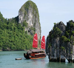
Van Phong Bay, impressive and unforgettable...
As http://www.vietnam-beauty.com/ From Nha Trang, driving some 50 kilometres toward the north, you will have a chance to discover Van Phong Bay, a wild and typical small paradise in Khanh Hoa Province.

An ideal bay...
Van Phong, called Port Dayot by French people, is located in Van Ninh and Ninh Hoa districts. There is a sand hill that is 18km long, situated between the main land and two islets creating a bay with a very beautiful landscape.
This beautiful landscape is endowed with wonderful natural sceneries and beaches of fine sand, an ideal temperate climate, surrounded by hills, mountains and tropical forests. The sea is all the more embellished with colorful coral reefs, vestiges of mangrove forests, rare sea creatures in an ideal environment. These are great potentials for the development of ecological tourism in Van Phong. In the plan toward the year 2010, Vietnam National Administration of Tourism declares Van Phong as "the most important region for tourism development". There are many forms of water sports and uphill tourism here, including sea diving, water skiing, sail boating, mineral water bathing and hunting. At present, Van Phong is ranked first of the four sea tourist centers by the Sea World Association.
Besides water and corals, the bay has more natural attractions. It is home to magnificent mountains with almost untouched forests and lovely beaches, and it is the habitat for hundreds of species of plants and animals. After exploring the ocean, you can walk along the white sandy beach, climb up the nearby mountain or observe animals in the island's forest. At night, you can stay in nice bungalows along the beach and eat seafood with Vietnamese.
An overview
Van Phong Bay, is geographically at the easternmost position of Vietnam, only 14 km from international waters and close to the junction of maritime routes. Van Phong is a big bay with 41,000 ha of water surface and a depth of 20-30 m and is relatively free from wind. Basing on these conditions and potentials, the Government has planned to establish in this area an international transshipment container port and a general multi-sectored economic complex of commerce, industry, tourism, etc. The container transshipment port of Van Phong, safe and airtight, is favorably coordinated with the land route, the railway, and the airway, fully able to compete with other container transshipment ports currently operating in the region such as Singapore, Hong Kong, Kao-hsiung. The container transshipment port of Van Phong is expected to reach 17.5-17.8 TEU/year. In addition, Van Phong is naturally endowed with a fairly mild climate and a beautiful environment with high potentials to develop eco-tourism and ideal conditions to develop aqua product economy.
The bay, surrounded by Hon Gom Island, has a rich terrain with islets, peninsulas, deep waters, coastlines, beaches and sand dunes. It is situated in a diverse eco-system with rain and mangrove forests. Van Phong is viewed as one of the most beautiful sea eco-tourism sites in Vietnam, due to its especially wild natural eco-system which is really rare in Southeast Asia. The beaches are large and nice with smooth white sand and blue water sea.
The weather in Van Phong is warm all the year round and the natural environment is almost intact and unpolluted, which is an ideal place for eco-tourism. Van Phong is in the centre of Southeast Asia, with almost the same distance to capitals of regional countries. This is an advantage to develop tourism because it takes tourists only two hours to travel by plane to the bay.
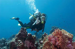
Scuba diving paradise on Vietnam's central coast
United Nations tourism experts have also recognised it as one of Asia's most perfect sites for eco-tourism, and the bay has been rated as an ideal place for scuba diving.
The bay is known for Hon Ong, Dam Mon and Bai Nhau. Hon Ong (whale island) is great for resting, enjoying the many beautiful sights and relics on the island. You can learn about the inhabitants' fishing work and the habits and customs of minorities living in the bay. For more entertainment, water sports, such as catamaran, windsurfing, scuba diving and snorkeling, are also on offer.

Scuba diving to the coral reefs, rowing boats and fishing squid or cuttle-fish at night are other activities at Dam Mon. From Dam Mon, you can also take a motorboat to discover the bay. You can also walk across the sand dunes toward Dam Mon Village. There you can stop for a while to learn about how the local fishermen smear chai (a material made from a plant) onto the bottom of their boats to make them waterproof. The perfect sunset view is from the top of the dunes.
It takes around 45 minutes to get to the first site of interest, Bai Nhau (Nhau beach), where you can see groups of white and pink jellyfish swimming in the calm water. Again you can also dive down to coral reefs.
If you spend some days in Van Phong, you have time to take trips to see many other islands in the bay, such as Hon Lon, Hon Do, Ganh Da, Bai Lach, Bai Me and Bai Ong Co, as well as fishing villages, lobster-breeding cages and pearl oyster-raising areas.
A report of the Vietnam Maritime Department shows that Van Phong is one of the world's deepest bays, a place of superlatives...
More photos here:
Edit by Teddy Lang!
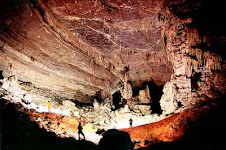
Son Dong, the world's largest cave

Son Doong cave, discovered by a local 18 years ago, is more than 200 meters wide, 150 meters high, and at least 6.5 kilometers long, though the explorers said they were unable to explore it fully. Bristish explorers have recently discovered that So Dong is much larger than the world’s biggest known cave. The biggest section of Son Dong is five kilometers in length, 200 meters high and 150 meters wide, said Howard Limbirt of the British Cave Research Association team searching the area April 10-14, 2009. Son Dong is much larger than Deer Cave in Malaysia, currently considered the world’s largest, an explorer said (Deer is 90 meters wide, 100 meters high and 2 kilometers long). The Son Doong cave has replaced to take pole position as the world’s largest cave.
The Son Dong is situated below another cave in Phong Nha-Ke Bang, though its entry passage is very difficult to traverse. The exploration team said they had set foot on just 6.5 kilometers along the cave, as there is a large amount of fast flowing water inside Son Dong. It takes explorers six hours of walking through a 10 kilometer long forest path from Truong Son Highway to reach the mouth of Son Dong cave. The explorer added that the Quang Binh cave has beautiful stalactites and stalagmites that are not seen anywhere else.
Phong Nha-Ke Bang grotto system belongs to the Phong Nha-Ke Bang National Park. It is a limestone region of 2,000 square kilometers in Vietnam and borders another limestone area in Hin Nammo in Laos. When describing the newly-discovered cave, the team’s spokesman, Haward Limbirt, said that it was a thing of overwhelming beauty and grandeur. He added that each grotto has its own beauty, but he is impressed by Ca Xai. This cave is near the Vietnam-Laos border. It is very deep and has a big lake inside. Explorers measured the depth of this lake, but they had only 200m of rope and the end didn’t reach the lake bed.
The British team suggested to the local authorities not to develop Son Doong Cave as a tourism site immediately to preserve its natural beauty.
Edit by Teddy Lang!
Hoi An ancient town

Lying on the banks of the Thu Bon River, Quảng Nam province ( in the South Central Coast of Vietnam), Hoi An Ancient Town is an exceptionally well-preserved example of a South-East Asian trading port dating from the 15th to the 19th century.
Over the last few years, Hoi An has become a very popular tourist destination in Vietnam. Its buildings and its street plan reflect the influences, both indigenous and foreign, that have combined to produce this unique heritage site. In 1999, the old town was declared a World Heritage site by UNESCO under the criteria C (II) and criteria C (V):
Criterion (II): Hoi An is an outstanding material manifestation of the fusion of cultures over time in an international commercial port.
Criterion (V): Hoi An is an exceptionally well preserved example of a traditional Asian trading port.
Occupied by early western traders, Hoi An was one of the major trading centers of Southeast Asia in the 16th century and 17th centuries, where Chinese from various provinces as well as Japanese, Dutch and Indians settled down.
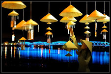
Light Bright
No fluorescent lights, no motorcycles, no television, on the 15th day of each lunar month, the riverside town of Hoi An gives modern life the night off.
In a wood-fronted shops a woman in traditional dress sits at a desk, bathed in the light of a lantern made from a simple bamboo fish-trap. Outside, two old men are absorbed in a candlelit game of Chinese checkers. Hoi An, a sleepy riverside town in the central province of Quang Nam. In the air of legendary, just experience the existence by tasting and feeling.
Hoi An has long been a cultural crossroad. More than five centuries ago the Vietnamese nation of Dai Viet expanded its territory southwards, encroaching on the Indianized Kingdom of Champa, which covered much of what is now central Vietnam. Hoi An, located on the Hoai River, emerged when Japanese and Chinese traders built a commercial district there in the 16th century.
These diverse cultural influences remain visible today. Visitors will find Hoi An's Old Quarter lined with two-storey Chinese shops, their elaborately carved wooden facades and moss-covered tile roofs having withstood the ravages of more than 300 years of weather and warfare. These proud old buildings, which back onto the river, remind visitors of another era, when Hoi An's market was filled with wares from as far afield as India and Europe. Colourful guildhalls, founded by ethnic Chinese from Guangdong and Fujian provinces, stand quietly, a testament to the town's trading roots.
While Hoi An's old-fashioned charm is always visible, on the 15th of every lunar month modernity takes another step back. On these evenings the town turns off its street lamps and fluorescent lights, leaving the Old Quarter bathed in the warm glow of coloured silk, glass and paper lanterns. In ancient times, Vietnamese people made lamps out of shallow bowls filled with oil. Later, foreign traders introduced lanterns, ranging from round and hexagonal designs from China to diamond and star shaped ones from Japan.
.jpg)
Let Hoi An be light
In the ensuing quiet the streets of Hoi An are at their most romantic, the darkness broken only by jeweltoned lanterns in all manner of shapes and sizes.
Strolling through the lantern-lit streets is like walking into a fairytale. It is all the more picturesque since motor vehicles are banned from Hoi An's Old Quarter. On Trai Phu Street, stop at the beautifully preserved Faifo Restaurant to sample some traditional Chinese-style pastries. Or walk on to the Treated Caf6, where bamboo baskets, commonly used to wash rice, have been transformed into unique lanterns. These basket lamps are but one example of people's creativity as they experiment with new shapes and materials, including lights made from hollow bamboo tubes.
.jpg)
A Warm Glow
Tourists can visit the relics of the Sa Huynh and Cham cultures. They can also enjoy the beautiful scenery of the romantic Hoi An River, Cua Dai Beach, and Cham Island.
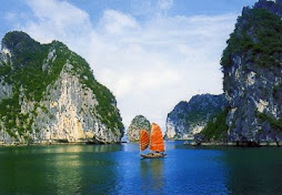
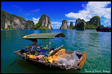
Ha Long Bay – a magnificent magical destination

Location & Climate
Ha long Bay is located in the Northeast of Vietnam, belonging to Ha Long city, Quang Ninh Province, in the Gulf of Tonkin. On the world map, it has borders to China in the North and adjacent to the East Sea in the East .
The Bay has a medium size of 1,553 square kilometers. It is accomodation of many fishing communities, including the 4 communes of Cua Van, Cong Tau, Vong Vieng and Ba Hang with a population of more than 1,600 people. The residents live on floating houses and boats, making their own lives by fishing and aquaculture.
The bay is a sea islands in tropical wet with 2 seasons: hot and moist summer, dry and cold winter. Average temperature is from 15°C- 25°C. Annual rainfall is between 2,000mm and 2,200mm. Halong Bay has the typical diurnal tide system (tide amplitude ranges from 3.5-4m). The salinity is from 31 to 34.5MT in dry season and lower in rainy season.
Historical name
Literally, “Ha Long” means "Bay of Descending Dragons." Before the 19th century, this name was not recorded in any document or archive. In this term, there is a mysteriously legendary tale as follows
“Long ago, in the first founding days, the Viet people were attacked by foreign aggressors. The Jade Emperor sent the Mother Dragon and her band of Child Dragons to help the Viet people fight the invaders. While the enemy vessels were launching massive attacks against the mainland, the dragons descended in flocks from the sky. They spat out innumerable pearls which changed into jade stone islands the moment they touched the water. These islands linked together to form firm citadels that checked the enemy’s advance and smashed their vessels to pieces. After the invaders were driven out, Mother Dragon and her Child Dragons did not return to Heaven but stayed on earth, right at the place where the battle occurred. The spot where the Mother Dragon landed was Ha Long, and where the Child Dragons came down was Bai Tu Long. The place where their tails violently wagged was called Long Vi, the today’s Tra Co Peninsula with its soft sandy beach stretching a series of kilometers.”
Gifted Beauty & top sightseeings

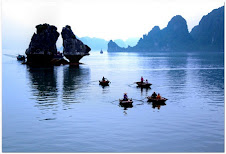
The dense cluster of 1,969 limestone monolithic islands within the bay is topped with thick jungle vegetation, which rise spectacularly from the ocean. Most of the islands were formed over 500 million years ago, and massed in the Southeast and Southwest. Those in the Southeast have an average height of 50-200m, covering lots of flora. Several of the islands are hollow, with enormous caves. Hang Đầu Gỗ (Wooden stakes Cave) is the largest grotto in the Ha Long area. French tourists visited in the late 19th century, and named the cave Grotte des Merveilles. Its three large chambers contain large numerous stalactites and stalagmites (as well as 19th century French graffiti). There are two bigger islands, Tuan Chau and Cat Ba, that have permanent inhabitants. Both of them have tourist facilities, including hotels and beaches. There are a number of wonderful beaches on the smaller islands. The others are Bai Chay, Ti Top, Minh Chau, Quan Lan and so forth.
Viewed from above, Ha Long Bay looks like an extremely vivid huge drawing, and sailing beneath the bay is like leisuring in between a huge valey on water. Ha Long bay is exactly a wonderfully skillful masterpiece of Nature that turns thousands of dumb soulless stone islands into fantastic sculptural and artistic works of various graceful shapes, both familiar and strange to human beings. Thousands of islands emerging in the fanciful waves look strong and magnificent but also mild and vivid. Amidst these islands tourists may feel as if they were astrayed in a petrified legendary world. The names given to the islands were based on their shapes and forms, such as, Human head Island, Sail island, Fighting cocks islands… Inside the stone islands are various breath-taking caves like Thien Cung, Dau Go, Sung Sot, and others. These are really magnificent palace of many huge stalactites hanging poised in mid air and stalagmites growing majestically upwards. Ha Long’s sea is always the same, blue, smooth and still.
What is more, the bay has its own seasoned beauty. In Spring, buds of trees burst on limestone islands. In Summer, it is cool and clean with many sparkling sun rays reflecting from the sea’s surface. In Autumn, especially at night, moonlight illuminates the mountains, making them like gold, inlaid into the earth. In Winter, with pervasive frost, Ha Long is glamorous as “a floating flower basket on smooth wave” (by writer Nguyen Tuan). All of them, stone, water and sky, make the Aesthetic value of Ha Long Bay.
The Bay’s Geological value is evaluated in two ways: by the history of its formation and its karst geomorphology. It is also home to the ancient Viet people beginning from 7,000 to 18,000 years ago, Ha Long’s Cultural − Historical value. Besides, Bio-diversity is an important natural resource, to be well-conserved so as to maintain the ecological balance of the whole region.
Ha Long Bay is undoubtedly not only a national but also a world nature, a magnificient work of Natural Creator. People who are admirers of natural beauty should stand up, pack their luggages, and right away pick up a flight to Ha Long, or else they will soon feel regretful!
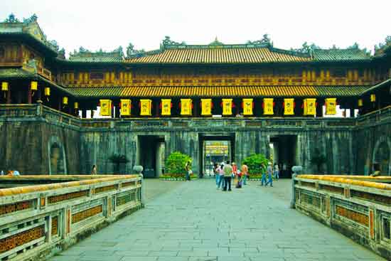
Hue, Imperial City
As http://www.vietnam-beauty.com/ - Still remaining its form of city underMidle Age and constructions of monarchic, a invaluable museum of Vietnam, this is imperial city - the last remaining section of 19th - century Hue, and it is now a modern experiment recreating traditional Vietnam. The imperial city was recognized as a World Cultural Heritage Site by UNESCO on December 1993. Let's take a trip through the most important historical and cultural monument Vietnam.
 Dominating the skyline is the 37m (120ft) high Cot Co or Flag Tower, first erected in 1809. Cot Co achieved international renown on the morning of 31 January 1968, when communist forces seized the Citadel and ran their yellow-starred banner up its tall mast.
The lower part of the gate is stone, while on top is the "Belvedere of the Five Phoenixes" where the emperor appeared on important occasions, and where the last emperor abdicated to Ho Chi Minh's Revolutionary Government in 1945.
Just inside the gate is a lotus pond with a bridge once reserved for the emperor's private use. Across the bridge is the Thai Hoa Palace used for official receptions and other important court ceremonies. The columns supporting the roof are lacquered and inlaid with gold.
Thai Hoa Palace
Behind the Thai Hoa Palace are a pair of smaller halls used by mandarins to prepare for court ceremonies. The halls form a courtyard, the fourth side of which was once a wall dividing the more public area of the citadel from the emperor's private residence, the "Forbidden Purple City." The name conjures up images of grand palaces like Beijing. Unfortunately, it takes quite a bit of imagination to picture the buildings that once occupied what is now a grassy expanse. What wasn't destroyed by a fire in 1947 was bombed in the 1968 Tet Offensive. The picture at above left was taken from the upper-most level looking back at the Thai Hoa palace and the Flag tower.
Off to one side of the central axis of the forbidden city, about midway, is the Thai Binh Lau or Royal Library. This small building stands in a garden and is fronted by small pond mostly taken up by a mountain-island well-grown with moss and bonsai. You will find similar ponds, fountains or even large bowls of water in many structures all over Vietnam.
Although you must enter the citadel through the main gate, you can exit it at several other points. Between the Thai Hoa palace and the halls of the mandarins, a path leads to the Hien Nhon gate (left). Leaving by this gate is the shortest route to get from the forbidden city to the museum at Long An palace. Along the path are a couple of buildings worth a look.
A visit to Hue might be considered incomplete without a boat trip on the outstandingly lovely Perfume River. Boats are readily available for hire, either for an exploratory trip in the vicinity of Hue, or for a longer journey upstream to the tombs of Minh Mang and Gia Long.
Perfume River

Perfume River
It's hard to explain the uncanny beauty of the river, though doubtless the irridescent, aquamarine waters, together with the profusion of colourful craft and boat women sporting non la--the ubiquitous cream-coloured conical hat of Vietnam--all contribute to the effect. On a clear, sunny day the Perfume River can indeed be magical.
More photos here: http://vnthuquan.net/diendan/tm.aspx?m=30368
Edit by Teddy Lang